Table of Contents
Introduction: Meghalaya
Meghalaya, a picturesque state in northeastern India, is renowned for its lush landscapes, rolling hills, and vibrant culture.
Known as the “Abode of Clouds,” Meghalaya is characterized by its dense forests, which are among the world’s wettest, particularly in places like Cherrapunji and Mawsynram.
The state is home to diverse indigenous tribes, primarily the Khasi, Jaintia, and Garo, each with rich traditions and languages.
Shillong, the capital, is often called the “Scotland of the East” due to its scenic beauty and colonial architecture.
Meghalaya’s unique attractions include the living root bridges, sacred groves, and breathtaking waterfalls, making it a haven for nature lovers and adventurers.
State Formation
Meghalaya, meaning “abode of clouds” in Sanskrit, was carved out of Assam on January 21, 1972, becoming the 21st state of India. The demand for a separate state for the hill tribes of northeastern India led to the creation of Meghalaya, which was initially an autonomous state within Assam from April 2, 1970, before achieving full statehood in 1972.
The State at a Glance

- Capital: Shillong
- Area: 22,429 square kilometers
- Population: Approximately 3.3 million (2021 estimate)
- Density: 132 Per Sq. Km
- Official Languages: English, Khasi, Garo, Pnar
- Major Cities: Shillong, Tura, Jowai, Nongstoin, Williamnagar
- Share Borders with:
- Assam to the north and east, and
- Bangladesh to the south and west.
Geography

Physiographic Regions and Topography
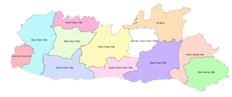
Meghalaya is part of the Indian subcontinent’s northeastern region and lies predominantly in the Shillong Plateau, an extension of the Indian peninsular plateau. The state is characterized by its hilly terrain and is divided into three principal hill ranges: the Khasi Hills, the Garo Hills, and the Jaintia Hills.
Garo Hills:
- Location: Western Meghalaya
- Significance: The Garo Hills are characterized by their dense forests and rich biodiversity.
- These hills are inhabited predominantly by the Garo tribe, who have a matrilineal society.
- The region is known for its cultural festivals, particularly Wangala, the harvest festival.
- The Garo Hills are also home to the Nokrek Biosphere Reserve and Balpakram National Park.
Khasi Hills:
- Location: Central Meghalaya
- Significance: The Khasi Hills are the most developed part of the state and include Shillong, the state capital. The Khasi tribe, known for their matrilineal culture, predominantly inhabit this region. The Khasi Hills are renowned for their living root bridges, which are a major tourist attraction. The area is also famous for its high rainfall, particularly in places like Cherrapunjee and Mawsynram, which are among the wettest places on Earth.
Jaintia Hills:
- Location: Eastern Meghalaya
- Significance: The Jaintia Hills are known for their rich mineral deposits, particularly limestone and coal. The Jaintia tribe, who share cultural similarities with the Khasi, inhabit these hills. This region is also famous for its numerous caves, such as the Siju and Syndai caves, which attract spelunkers from around the world. The Nartiang Monoliths, a collection of ancient stone structures, highlight the historical significance of the Jaintia Hills.
Lakes
- Umiam Lake (Barapani):
- Location: Near Shillong, East Khasi Hills
- Significance: A man-made reservoir created by damming the Umiam River, Umiam Lake is a major tourist attraction. It is known for its picturesque scenery and is a popular spot for water sports, boating, and fishing.
- Ward’s Lake:
- Location: Shillong
- Significance: Also known as Pollock’s Lake, this artificial lake in the heart of Shillong is surrounded by a well-maintained garden and walking paths. It is a popular recreational spot for both locals and tourists.
- Dawki Lake:
- Location: Near Dawki, West Jaintia Hills
- Significance: Famous for its crystal-clear waters, Dawki Lake is fed by the Umngot River. The riverbed is so clear that boats appear to be floating in mid-air. It’s a favorite destination for kayaking and boating.
- Nongkhnum Lake:
- Location: West Khasi Hills
- Significance: The largest river island in Meghalaya, created by the bifurcation of the Kynshi River. Nongkhnum is known for its scenic beauty, sandy beaches, and cascading waterfalls.
National Parks and Wildlife Sanctuaries
- Balpakram National Park:
- Location: South Garo Hills
- Significance: Known as the “Land of Spirits” to the Garos, this park is rich in biodiversity and is home to a variety of wildlife including elephants, tigers, leopards, and the rare red panda. The park’s unique landscape features deep gorges and limestone cliffs.
- Nokrek National Park:
- Location: West Garo Hills
- Significance: Part of the Nokrek Biosphere Reserve, this park is known for its rich flora and fauna. It is a habitat for the endangered red panda and Asian elephants. The park also has a significant population of citrus-indica (wild orange) which is considered a genetic origin for all citrus fruits.
- Siju Wildlife Sanctuary:
- Location: South Garo Hills
- Significance: Known for the Siju Caves, which are some of the longest caves in the Indian subcontinent. The sanctuary is home to a variety of bird species, making it a bird watcher’s paradise.
- Narpuh Wildlife Sanctuary:
- Location: East Jaintia Hills
- Significance: This sanctuary is known for its rich biodiversity, including a variety of orchids and medicinal plants. It is home to several species of wildlife such as the Hoolock gibbon, slow loris, and the black bear.
Waterfalls
Meghalaya is home to numerous stunning waterfalls, each contributing to its reputation as a haven for nature enthusiasts. Here are some of the major waterfalls in the state:
Nohkalikai Falls
- Location: Near Cherrapunji, East Khasi Hills District.
- Height: Approximately 340 meters (1,115 feet), making it the tallest plunge waterfall in India.
- Fed by rainwater collected on the summit of a relatively small plateau.
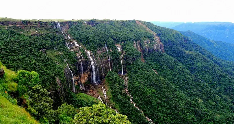
Seven Sisters Falls (Nohsngithiang Falls)
- Location: Near Mawsmai village, Cherrapunji, East Khasi Hills District.
- Height: Approximately 315 meters (1,033 feet).
- River: This waterfall is part of the Mawsmai river system.
Dainthlen Falls
- Location: Near Cherrapunji, East Khasi Hills District.
- Height: Around 90 meters (295 feet).
Elephant Falls
- Location: Near Shillong, East Khasi Hills District.
- Height: Approximately 40 meters (131 feet) across three cascades.
- River: Part of the Umshyrpi River system.
Kynrem Falls
- Location: Thangkharang Park, near Cherrapunji, East Khasi Hills District.
- Height: Approximately 305 meters (1,001 feet).
- River: Flows from the Thangkharang River.
Langshiang Falls
- Location: Near Sangriang village, West Khasi Hills District.
- Height: Around 337 meters (1,106 feet).
- River: Formed by the Kynshi River.
Bishop and Beadon Falls
- Location: Near Shillong, East Khasi Hills District.
- Height: Both waterfalls have heights around 135 meters (443 feet).
- River: Both are fed by the Umiam River, with Beadon flowing into Bishop, creating a dramatic series of drops.
Krang Suri Falls
- Location: Near Jowai, West Jaintia Hills District.
- Height: Approximately 40 meters (131 feet).
- River: Formed by a tributary of the Myntdu River.
Sweet Falls
- Location: Near Shillong, East Khasi Hills District.
- Height: Approximately 96 meters (315 feet).
- River: Fed by the Umkhen Stream, a tributary of the Umiam River.
Weisawdong Falls
- Location: Near Sohra, East Khasi Hills District.
- Height: Estimated around 60 meters (197 feet) with three distinct tiers.
Geology
Meghalaya’s geological structure is significant due to the Shillong Plateau, composed mainly of Precambrian rocks, including gneiss and granite. The region is also noted for its coal and limestone deposits, which play an essential role in the state’s economy.
Important Rivers
Meghalaya’s rivers are integral to its geography and culture, often flowing southwards into Bangladesh.
- Brahmaputra River: The Brahmaputra does not flow directly through Meghalaya but influences its northern region.
- Umngot River: Known for its crystal-clear waters, it flows from the East Khasi Hills into Bangladesh.
- Myntdu River: Originating in the Jaintia Hills, it is a major tributary of the Meghna River in Bangladesh.
- Simlieng River: Flows through the Garo Hills, joining the larger Brahmaputra system.
Read More: Rivers of Meghalaya
Economy
Meghalaya’s economy is primarily agrarian, with agriculture engaging the majority of its population. The state’s economy is supplemented by forestry, mining, and tourism.
- Agriculture: Major crops include rice, maize, potatoes, and horticultural produce like oranges, pineapples, and bananas.
- Forestry: Timber and bamboo are significant resources.
- Mining: Coal, limestone, and uranium are key mineral resources.
- Tourism: Attractions include the Living Root Bridges, Mawlynnong (Asia’s cleanest village), and the wettest place on earth, Mawsynram.
Important Cities
- Shillong: The capital city, known as the “Scotland of the East,” is a cultural and educational hub with institutions like North-Eastern Hill University. Attractions include Elephant Falls, Shillong Peak, and the vibrant local markets.
- Tura: The administrative headquarters of the West Garo Hills, known for its rich biodiversity and Nokrek Biosphere Reserve.
- Jowai: A prominent town in the Jaintia Hills, known for its scenic beauty and the Syntu Ksiar, a picturesque lakeside area.
- Nongstoin: The headquarters of the West Khasi Hills, notable for its natural beauty and cultural heritage.
- Williamnagar: An important town in the East Garo Hills, known for its serene environment and proximity to various natural reserves.
